Route

Route
Jonathan and Kirti Walpole's 950 km canoe journey across Northwest Territories and Nunavut in July and August of 2014

Day 7

Weather: 3 degrees C in the morning, but calm and sunny all day
Distance: 15 km paddling, plus 1 km portage (5 km walking)
Location: Latitude:63.55765, Longitude:-105.53441 at 07/19/2014 18:13:11 PDT
Map link: Click here

It was a cold night, with the temperature dropping to just 3 degrees C. The weather was calm and sunny all day though, and warm, but not too hot. We got a late start and weren't on the water until 10 am. It took us an hour to cross Hanbury Lake. Shortly after that we encountered the first part of Caribou Rapids.

We stopped to scout the first 1 km or so, but were able to run most of it and line the last part on river left. Then, after a wide pool, the main drop began and this was a definite portage on river right. This is a beautiful area with spectacular rapids and a relatively easy portage under 1 km. The portage required about 3 hours of hard labor to complete.

After the main drop there are a couple of km of easier rapids and boulder gardens that demand a certain amount of technical rock dodging, but were clearly runnable for us. Here the river is wide and very shallow, with a rocky bottom. We guessed that the caribou could probably walk across the river here.

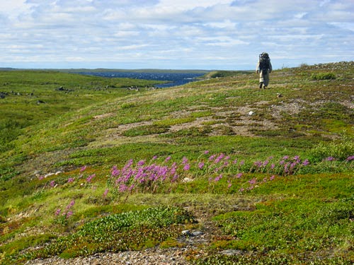
Below the rapids there were a few km of gentle current. Later, we camped at a beautiful esker beside a lake and enjoyed a lovely late evening hike along the top of the esker. The light was gorgeous, and as usual, darkness never came.

Day 6

Weather: gale force westerly winds
Distance: 24 km paddling, plus 15 km walking
Location: Latitude:63.57511, Longitude:-105.72670 at 07/19/2014 08:09:11 PDT
Map link: Click here

Today we did really well to make progress in conditions that should normally have restricted us to land. The wind was fierce, around 30 knots out of the west. This was a tailwind, but it was so strong that it would be unsafe to be on open water in a canoe. However, we managed to figure out a circuitous route, made up of narrow channels, lake shores along which we could handrail and shelter from the wind, and very short crossings in which the wind was directly behind us and in which we could literally surf on breaking but manageable following seas. In this way, we were able to paddle to the first portage of our trip, here and complete it in cool, windy, bug-free conditions.

The portage was under 1 km in length, and enabled us to negotiate an unrunnable, but very scenic waterfall. There was no trail, but the conditions under foot were reasonably friendly and there was relatively little elevation gain or loss involved. All of our training and preparation for portaging paid off, and the portage went smoothly. It was, however, too windy to carry the canoe in the normal way. The windage of the canoe was such that in these gale force winds you would quite litterally be blown over if the canoe turned sideways to the wind. Trailing a line from the stern (it was a tail wind), so a second person could keep the end of the canoe pointing into the wind like a weather vein, allowed us to get the canoe to the other end, but we need more practice at this.

With the first portage complete, were were then able to continue our careful strategy of using terrain to keep out of the wind where possible, and surfing when we were crossing with the wind behind us, in order to reach Grove Rapids, the second portage of our journey. This second portage is about 2 km long with much more elevation change (gain and loss). It starts out following the top of an esker, which makes conditions underfoot very nice and smooth. The esker does not, however, follow the river. So it is an interesting overland journey through scenic terrain of small lakes and craggy hills. Eventually you climb to a ridge from which you have an extensive view down to Hanbury Lake. The descent goes across rocking ridges, small crags and through some boggy areas before arriving at a very steep lake shore with small cliffs. We found a sheltered place to camp with beautiful views over the lake, and left the task of lowering the canoe and gear to the water until the morning.

Portaging the bags was a fairly straightforward, albeit tiring, process. In practice, 2 km feels much longer than it sounds in theory. This is especially true when you are lugging a 70 lb bag on your back, but we had trained well enough to be able to do each pass without stopping to rest. Portaging the canoe was challenging though. The gale force winds on the esker were so fierce that they made shouldering the canoe impossible. This was partly due to the strength of the wind and partly due to the direction (a cross wind in places). So we were forced to do a two person carry using the handles at each end of the canoe. The portage was broken into many short sprints, before putting the canoe down, changing hands, and sprinting again. From the top of the ridge I then dragged the canoe downhill over the tundra and boggy areas. This was actually easier than carrying it. All in all, this portage took us about 4 hours and involved 10 km of walking (three journeys with load and two returns).

We were very happy to have been able to make such progress on such a fierce windy day, while minimizing our exposure to danger. Due to our wind evading strategies, we probably paddled at least 5km further than necessary, but that is what made the journey possible on a day like this.

The area around Hanbury lake is beautiful, as is Grove rapids, and the esker we portage along. There are a few groves of very small spruce trees which is quite unexpected after the last few days of spartan tundra scenary. We are now laying in the tent on a thick bed of soft, spongey, moss, maybe a foot or two thick. It is like sleeping on a giant water bed, and is oh so comfortable after two strenuous portages and 24km of paddling in gale force winds.

Day 5

Weather: Sunny, very windy
Distance: 2km
Location: Latitude:63.65110, Longitude:-105.96355 at 07/17/2014 18:34:09 PDT
Map link: Click here

Although the weather was clear and sunny, the wind was still blasting and the lake surrounding the island we were on was covered in whitecaps. It was too rough to paddle, and the fierce wind would have been a headwind anyway, strong enough to prevent any progress by canoe. So, this was a day for hiking! Unfortunately, we were on a small island with no way off. After 30 minutes we had hiked the whole thing. That was bad planning. So we hung around and waited for the wind to drop. It was pleasant and relaxing, at least, with no bugs.

We had breakfast, then hiked around a bit. Then lounged around, then had lunch. Then we watched a ptarmigan for a while and hiked around some more. Eventually, by late afternoon the wind subsided slightly, so we quickly packed up and paddled away from the island to a slightly better (more protected) location on a larger island about a mile away. By the time we got there the weather had deteriorated again and we found ourselves setting up the tent again in a hurry and preparing for another onslaught of wind and rain.

Another thunderstorm came through with fierce wind and torrential rain. It was the full fire-hose treatment again, but this time were were in a slightly more sheltered position so it was easy to weather it out. Then it calmed down for a while, then we had another thunderstorm. The storms came one after another all evening. There was nothing to do other than wait in the tent with everything locked down. We caught up on our study of the history of the Thelon river, which Kirti read out loud from our kindle.

Day 4

Weather: Poor visibility, rain, moderate wind, then intense storm, thunder, lightning, storm-force winds
Distance: 30 km
Location: Latitude:63.63982, Longitude:-105.96906 at 07/16/2014 17:51:00 PDT
Map link: Click here

We set off today just after 8 am. It had rained overnight, but was not raining when we started, however it soon started to rain and we wore our bibs and rain jackets to paddle. We paddled through many small channels, some of which had current in spots, and one even had a small rapid. After lunch we saw storm clounds gathering and we heard thunder. We decided to get off the water, and it was a good job we did. The sky turned black and a huge storm errupted.

We were not in a very good location for shelter, but it had to do. Because there were few suitable spots for a tent, we put up the flysheet of the kitchen shelter for initial shelter from the wind and rain, in the hope that the storm would pass and we'd be able to find a more suitable camp later. However, the storm became very intense with the wind swinging around from the North to the Northwest and gusting up to at least 100 km/hour. Despite piles of large rocks on the tent anchors, and additionally guy lines deployed, we still found ourselves inside the tent having to lean against the windy side of the tent just to hold it up, while a veritable fire-hose of rain created a deafening roar. This lasted for several hours. Enduring the full brunt of a storm, fully exposed on the relatively featureless tundra, is something we expected and had planned for, but it was still more than a little unnerving, since we were not well located for this.

By 10 pm the rain had stopped, the storm had subsided, and the wind had dropped to mere gale force. We hiked around and found a half-decent spot for our sleeping tent, pitched it (which was a bit tricky in the strong winds) and snuggled inside. It was very comfortable, and for once, there was no sign whatsoever of any bugs. The temperature dropped rapidly.

Day 3

Weather: Calm, smokey, hot, buggy
Distance: 37 km
Location: Latitude:63.70515, Longitude:-106.38274 at 07/15/2014 18:14:34 PDT
Map link: Click here

The visibility was very poor today, under 400 meters all day. It was like paddling in fog on the sea, but here the poor visibility was due to smoke that blew in from the south yesterday. Navigation was challenging. It was also hot and muggy all day, and conditions were totally calm, so we were surrounded by a dense cloud of blackflies all day. Occasionally unzipping the face shield of my bug suit to be able to see to navigate, resulted in a lot of bug bites on my throat and under my chin. These soon swelled up and were really itchy and annoying. The smoke was so thick that you could look directly at the mid day sun with the naked eye. It was just a dull red ball in the sky. Much of the day the visibility was too low to be able to see any scenary or wildlife. We did however spot a stoat on shore and several loons on the water.

We stopped for lunch on an esker here and had to set up the bug shelter in order to be able to eat. Drinking could be done through the mesh of the bug suit, but eating was more challenging. We felt as if we were under seige.

After lunch we paddled 10km and then stopped at an esker to hike.

Later we camped on another esker. Again we set up all three tents - sleeping tent, kitchen tent, and bathroom tent. We had a good bug-free wash in the bathroom tent, and long bug-killing sessions in the kitchen and sleeping tents.

Dinner was butternut and leak soup with barley. Very nice! By 10.30 pm the temperature in the tent had dropped to 70 degrees.

Day 2

Weather: Clear, sunny, windy, then smokey, calm, buggy, and eventually cloudy with some rain.
Distance: 46 km
Location: Latitude:63.57298, Longitude:-106.82217 at 07/14/2014 20:22:39 PDT
Map link: Click here

We launched at 7 am and quickly found the start of the Hanbury River in a quiet corner of the lake. At first there was just a slight hint of current in shallow water, then the waterway narrowed, rounded a corner and we found ourselves on a small, shallow river with frequent shallow rocky rapids. The action and the intimacy of the river was a wonderful change from the lake paddling we had yesterday. However, it soon became apparent that this really was a very low water year and that some of the rapids may not be runnable. At one stage we had to line and wrestle the canoe down a shallow set of rapids for 1 km or so. Several such sections ensued, and in between we had to be very vigilant about rocks and shallows, constantly keeping our speed in check by back setting. The Pakcanoe handled very well in these conditions, but whenever it ran aground, either with us in it or without, it did not slide over rocks and was quite difficult to drag through the shallow rocky rapids. In particular, it is not easily pulled sideways over shallow rocks like a hardshell is.

We soon entered Heuss Lake, followed by Smart Lake. The wind got up and was blowing quite hard from the side for a few km. Eventually, we had quartering seas and enjoyed the lively waves, trying to milk as much energy as we could. The wind got up to 20 mph and was fairly constant, setting up some nice rolling wave trains with small whitecaps.

We stopped for lunch at an esker where we saw a lone muskox. I carefully approached it, for photos, probably closer than I should have. It jumped up and ran back a bit before facing me. I quickly retreated. So did it. Later we saw it on the other side of the esker. It was quite animated, charging back and forth and rolling around in a big sand pit. It was much more energetic than we expected.

At this stage the weather was clear and sunny, with temperatures around 80. We had a nice lunch on the esker, and it was windy enough to keep the bugs at bay.We launched after lunch and enjoyed a few km of following seas, with fairly large waves. We were on the brink of being surfed a few times, but the Pakcanoe it not quite fast enough (especially when heavily loaded) to break free and surf easily. The energy spent trying to accelerate it up to surfing speed was probably not well spent, but we kept trying nevertheless.

By mid afternoon the south wind blew in a huge bank of smoke from the extensive forest fires to the south of us. Visibility dropped drastically, to 400 meters or less. It became quite difficult to navigate, and air quality was poor. The sun was a barely visible red ball in the middle of an otherwise cloudless sky. The wind dropped and the bugs came out in force. We eventually stopped at 7pm.

Later in the evening there was some thunder and a brief rain shower. The bugs were ferocious in the later part of the day, both on and off the water, and we had to seal up the hoods and face shields of our bugsuits and put our leather gloves on for the last couple of hours of our paddle, even though we were out on a lake.

Day 1

Weather: sunny, high 70s
Distance: 25 km
Location: Latitude:63.27299, Longitude:-106.88620 at 07/13/2014 10:22:40 PDT
Map link: click here

We met Dave Oleson at the float plane dock in Yellowknife at 8am. Chuck Tolley dropped us off, which made the logistics much more manageable. We loaded and fueled the plane, then took off around 9am. High winds, from the south, gusting 25 to 30 knots out on the lake, made the take off a little challenging, but we had some sheltered water in the bay. Dave said if the wind and waves got up much more then small planes like his would not be able to take off. Luckily we got away early enough and it was going to be calmer where we were heading. Dave was really well organized, safety concious and professional (just as we had heard). We were really happy to be flying with him. The flight was excellent. It was really smooth and neither of us had any hint of travel sickness, which we had been worried about beforehand.

Our flight path took us over the north shore and east arm of the Great Slave Lake. It looked beautiful, and would make an excellent canoe or sea kayak trip in its own right. We also saw a lot of forest fires, including the one that took Dave's home and guest cabin just a few days before. The smoke was blowing north, towards the tundra. We were worried that our trip might be affected by this.

We arrived at Campbell Lake around 11am. Dave found a suitable place to land beside a beautiful esker, and taxied the plane to a rocky shore where he could run the floats right up to the shore, enabling us to disembark without even getting our feet wet! Perfect service!

We unloaded the luggage and then watched as he taxied away , took off and disappeared into a clear blue sky. Once he had gone there was total silence. The lake was mirror calm and the lovely aroma of the tundra's aromatic plants filled our nostrils.

We spent an hour or so organizing our stuff, building the canoe, loading the bags, and fitting the spray deck. Once we were ready to leave it was time to make sure we knew precisely where we were. We didn't want to start out lost! As expected, we were close to the western end of Campbell Lake, right where we asked Dave to drop us, right here.

We paddled just over 25 km in about 4 hours, all on Campbell Lake. The weather was warm and sunny, and a light wind picked up to about 10 mph, creating side and quartering seas, just big enough to allow us a bit of assistance if the stern paddler kept the canoe aligned well enough for some diagonal runs. We are now camped about 1 km from the start of the Hanbury River and are eager to find out if it has enough water in it! Afterall, this is an exceptionally dry year. We are on a small headland with nice views all around. Our position does not offer much, if any, shelter, but the weather looks excellent and we hope to leave early in the morning.

The bugs have not been bad today. There have been a few, but they are easy to deal with. By 9pm the mosquitos are out, but we were already cozy in our tent and are now watching a nice sunset. The ground under the tent is dry but spongey, creating a plush 6" thick matress under our thermarests. The smell of the tundra plants is wonderful!

Today's wildlife consisted of many flightless geese and arctic terns.

We're Off!

This is the last post before we leave. We are flying out of Yellowknife at 8am tomorrow morning. After that you should, hopefully, see a SPOT message from us posted here most days. We may also occasionally send a message using the inReach device, which will appear on the location map in the right hand column of the blog (you'll have to click on the map and then click on the arrow representing the message).

We had a lovely day today with Chuck and Muriel. We went to the Yellowknife air show this morning, then had a nice guided tour around Yellowknife, a lovely dinner, and an evening viewing some pictures of Baker Lake and the Inuit Chuck and Muriel knew there from their years of living and teaching there in the 1960s and 1970s. They have some fascinating pictures that give a very intimate insight into the history of the place and its people.

Made it to Yellowknife!

We are finally in Yellowknife. It was a loooong drive! The only road into Yellowknife was closed today, due to forest fires, but fortunately for us, this happened just moments after we passed by the fire. The fire was almost at the road, with towering columns of dense smoke almost engulfing the road, as we drove by. Moments later we heard on the radio that the road was closed. That was close!

Aside from that we spent hour upon hour driving on straight roads with wide grassy shoulders and dense forests of small trees. It was hundreds of kilometers between gas stations. This aspect of the drive was pretty monotonous apart from a few points of significant interest - such as crossing the mighty Mackenzie river, which is enormous, our first views of the Great Slave Lake, which is enormous too, and this impressive and unexpected little waterfall on the Slave river. This really appeared out of nowhere!

The other memorable aspects of the past two days driving were the sheer scale of it all, and the ferocious swarms of horse flies that would engulf the car the moment we stopped anywhere, or even slowed down. This only started happening once we were in the Northwest Territories. Filling up at Fort Providence was a bit of a trial. Soon, however, we realized that they were really more interested in the car, and the dead insects all over it, than in us. Away from the car they didn't bother us at all, but summoning up the courage to get out of the car was the challenge (and back into it). Before we realized this we were marvelling at the toughness of Canadian flaggers who would stand out in the road dressed only in shorts and a T shirt and apparently not bat an eye to the bugs, while we cowered in our car surrounded by hoards of ferocious horse flies hammering on the windows. Also, while we were driving, the sound of bugs on the windscreen sounded like driving in a rainstorm.

Oh, and we saw a huge bison right by the roadside.

We are staying in Yellowknife with Chuck and Muriel Tolley, who are wonderful people. We have only done a brief tour so far, but Yellowknife seems to be a very nice town. Oh, and our float plane pilot, Dave Oleson, has very generously agreed to honor our arrangements and fly us out to the Hanbury river, despite having lost his home and guest cabin to a forest fire just a couple of days ago. What a guy!