Route

Route
Jonathan and Kirti Walpole's 950 km canoe journey across Northwest Territories and Nunavut in July and August of 2014

Day 18

Weather: Smokey, hot, moderate wind and swell from the South, getting stronger by mid day
Distance: 49 km
Location: Latitude:64.53829, Longitude:-99.00211 at 07/30/2014 19:55:27 PDT
Map link: Click here

We got up early and were on the water by 3.45 am today. This was motivated by the prospect of paddling a very large expanse of exposed coastline. The wind and waves were coming from the south (on shore) and there was a 2+ foot swell rolling in. It was foggy or smokey or both and it felt much more like sea kayaking than river or lake canoeing. As experiences sea kayakers we felt at home in this environment, but couldn't help feeling that we were in the wrong craft for this. A canoe is too slow, too vulnerable to breaking waves, and has too much windage for exposed open water paddling.

The north shore of Aberdeen Lake is very shallow, with gravel and boulder bars extending out from shore 1 km or more much of the time. This meant that the south swell was steep and breaking quite far out from shore, so we had to paddle well away from shore in places. This made us quite exposed to sudden changes in wind direction (i.e. a wind from the north). The lake is huge and it was not possible to see the southern shore, even from high on the north shore.

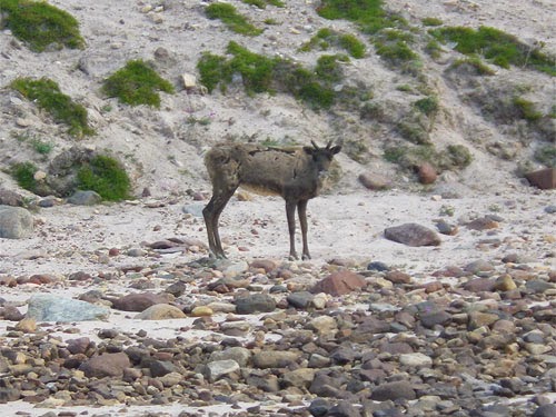
Kirti found the conditions very challenging, with large waves from the side and intermittent surf and shoaling areas. The shallow areas also created a lot of hull-drag and made our progress slow. The wind picked up and it was hard to make any progress. At 10.30 am we decided to stop. We set up the tent to protect us from the bugs, which were surprisingly aggressive given the wind. We stopped here for several hours and had a meal and a snooze. We found a bird tag on the beach and saw another caribou.

The wind dropped slightly by mid afternoon and we decided to break camp and push on, given that we had about 60 km of exposed coastline to negotiate. We paddled for another 3 hours and covered 14 more km. It was difficult to find a good camping area as the shore was very low lying and the water level seemed to have recently dropped, so there were extensive wet, mossy, muddy areas.

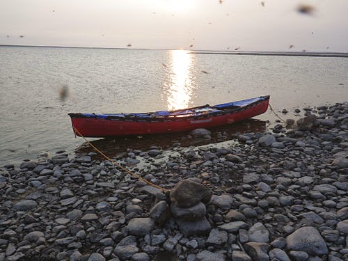
Eventually, we found a camp. The black flies were horrendous - the worst yet. Without the bug shelter we would be eaten alive. Kirti reiterated her conviction to never come to the Thelon again.

Day 17

Weather: Hot, calm, muggy and buggy with smoke that limited visibility.
Distance: 45 km
Location: Latitude:64.61521, Longitude:-99.74786 at 07/29/2014 15:27:11 PDT
Map link: Click here

The weather was calm, hot, muggy, buggy and smokey yet again. We started paddling at 6.50 am and navigated through a maze of islands that is marked as the Thelon River, but is really an island filled lake. Most of our journey was not very exposed.

We ended the day at the start of Aberdeen Lake, which is a huge lake. It feels more like the sea than a lake. We saw two caribou, two arctic hares, some loons, sea gulls, eagles and arctic terns. The hares are enormous, like gigantic bunny rabbits.

We are camped on the tundra at the start of a peninsula. We walked out to the end of the peninsula in the evening, a round-trip distance of 6 km, and saw several tent rings and signs of older native settlements. In many of these areas there were a lot of broken caribou bones. We also saw several dumps of steel fuel drums, dozens of them, and one abandoned canoe out in the middle of the tundra.

Day 16

Weather: Very hot, calm, muggy and buggy
Distance: 55 km
Location: Latitude:64.58147, Longitude:-100.42728 at 07/28/2014 16:08:33 PDT
Map link: Click here

We had another early start and were on the water before 6 am. We paddled through an easy class 2 rapid at Thelon Bluffs, then paddled with the current to the start of Beverley Lake. There was a huge estuary area approaching Beverley Lake with extensive sandbars. It was quite tricky navigating in order to stay in the deep channels. For the past two days we have been dive-bombed by sea gulls protecting their nests.

We crossed to the South shore of the lake and hand railed along that shore for a few hours. It was hot, muggy, and calm again. The barometer has been steady for the past 6 days. We decided to push in order to get past the exposed part of Beverley Lake before the wind got up. We eventually stopped to camp on a small island at the east end of Beverley Lake. We had to go into the water multiple times to cool off.

Day 15

Weather: Sunny, hot, light wind.
Distance: 85 km
Location: Latitude:64.52709, Longitude:-101.25607 at 07/27/2014 20:55:09 PDT
Map link: Click here

Once again it was a hot, sunny day. We were on the water before 6 am. There was good current for the first few km and we ate breakfast while floating effortlessly down stream. The river bed looked beautiful speeding by below us through crystal clear water. We had decent current for most of the day, but not always. There were also some still pools that lasted several km at a time.

Finally, we saw a caribou. It was just a lone animal, but it would have been embarrassing to paddle almost 1000 km through one of the largest wildlife sanctuaries in the world without seeing a single caribou. We were relieved. It looked pretty miserable though, being plagued by millions of black flies. We knew how it felt.

Early in the afternoon we saw our first people of the trip: a group of four canoeists, in two canoes, from Fort Smith, NWT - Adam, Hillary, Elena and Jonah. We stopped to chat and share their enormous bug shelter for a few minutes. They had come down the Elk River before joining the Thelon and were also planning on paddling all the way to Baker Lake. After our stop with them we paddled another 4 hours around Ursus Island and finally stopped around 7pm.

Ursus Island was spectacularly flat and low-lying, especially at its downstream end. The massive sand spits and huge expanses of shallow water merged into one with the sky and it was dizzying trying to focus on anything. It became impossible to judge distance or even see the boundaries between water, land and sky. It was quite disconcerting, but beautiful in an other-worldly kind of way.

We are camping near Thelon Bluffs. The black flies are horrendous, swarming and crawling on everything. Despite our best efforts, thousands have found their way into our bug shelter and we are having to spend most of an hour hunting them down and killing them before we can relax. Kirti has vowed to NEVER come here again!

Day 14

Weather: Hot, muggy, buggy, light tail wind in the morning, then strong headwind in the early afternoon, then tailwind again.
Distance: 80 km paddling plus a 6 km hike
Location: Latitude:64.17626, Longitude:-102.46298 at 07/26/2014 17:26:41 PDT
Map link: Click here

We woke at 4.30 am and were on the water, paddling, by 5.15 am. With the help of the current and very light wind we averaged almost 10 km per hour for a couple of hours, then 8 km per hour after that. We were only paddling at a 5-6 km per hour effort level, so the current was quite swift. It didn't last for ever though.

We saw another grizzly bear on river right, very close to us. It was near the water and we were running along the right bank. We only saw it at the last minute, as we passed it. It seemed as surprised as we were and it woofed and ran away.

We stopped to hike at Muskox Pingo. We had been told that muskox were common around here and were eager to see some. By this stage we were getting quite disappointed by the relative lack of wildlife. We were several hundred km into the Thelon Wildlife Sanctuary by now and had not seen a single caribou or muskox. The muskox we had seen was near the start of the Hanbury, way outside the wildlife sanctuary. So, we thought we needed to get out and search more aggressively. The hike to Muskox Pingo was a 6 km round trip across the tundra. In places it was quite tussocky and difficult going. It was also very hot and buggy. We found the Pingo and more importantly, managed to find our way back to the canoe afterwards (always carry a map and compass on these hikes!). Unfortunately, we did not see any wildlife whatsoever. We decided to rename this "The Thelon Bug Sanctuary".

The wind picked up and the river switched direction directly into it for the next 10 km. Without current assistance we probably would have been forced to stop, but we battled through breaking waves for 10 km and then turned to have the wind behind us again for the rest of the day. With the gentle wind and current assist, Kirti was able to take a well-earned break for a while.

We passed Lookout Point and enjoyed the scenery. We eventually stopped to camp on a beautiful esker with the river and a white sand beach to one side and a lake to the other. This was a beautiful spot. We enjoyed a swim in the river. The water temperature was perfect. Since the weather was so hot we decided to sleep in our mesh tent again. It was lovely lying in bed looking at the sunset and watching for wildlife.

Day 13

Weather: Hot, calm wind, buggy.
Distance: 66 km
Location: Latitude:64.28446, Longitude:-103.52542 at 07/25/2014 14:52:10 PDT
Map link: Click here

We were up early and on the water by 6am. There was no current for the first 20 km, so despite being on the Thelon "river" it was really like paddling down a long, narrow lake. We started to get a bit worried about the effort required to cover the remaining 600 km of our journey. We were working hard to average 6 km per hour. On the positive side, though, the surface was like a mill pond and the reflections were fantastic.

After 20 km the current started to pick up a bit and we enjoyed watching the banks pass by at a greater speed and the river bed pass beneath the hull of the canoe in a kaleidoscope of colorful rocks and pebbles. We saw a grizzly bear on river right. It stood up on its hind legs to get a better smell of us, and then turned and ran off. Can't blame it, really. We'd been sweating in these bug suits all day, every day, for almost 2 weeks. We also enjoyed frequent sightings of peregrine falcons, bald eagles, arctic terns, swans, and canada geese.

We stopped to camp high above the river on river right. The wind dropped and the black flies came out in force. It was another sweltering, hot, calm evening. Since it was so hot we decided to sleep in our Hex 3 mesh tent. The view from bed was fantastic and the mesh kept the swarms of black flies at bay. Other than the occasional bird and the constant hum of the black flies it continues to be absolutely silent. Still no sign of humans apart from us.